


جبل جاشك الملحي

| جبل جاشك الملحي | |
|---|---|
 جبل جاشك الملحي
|
|
|
|
|
| الموقع | مدينة بوشهر الساحلية |
| إحداثيات | 28°15′N 51°42′E |
| السلسلة | سلسلة جبال زاغروس |
| النوع | جبل |
| قائمة | قائمة التراث الوطني |

|
|

جبل جاشك الملحي أو (قبة جاشك الملحية)، هو أحد أكبر الجبال الملحية في منطقة الشرق الأوسط وإيران[1]، والذي يغطي جزء من جبل جاشك الذي يقع في نهاية سلسلة جبال زاغروس بمحافظة بوشهر جنوبي إيران. يُعتبَر هذا الجبل الفريد من أكثر الجبال الملحية نشاطاً، وقد تم تسجيله عام 2007 في قائمة الآثار الطبيعية في إيران باعتباره معلماً وطنياً طبيعياً.[2]
جبل جاشك الملحي، هو احد اكبر الجبال الملحية في الشرق الأوسط
الموقع
يقع جبل جاشك الملحي على الطريق الواصل بين مدينتي دير ودشتي وعلى بعد 144 كيلومتراً جنوب شرق مدينة بوشهر جنوب إيران بمحاذاة مياه الخليج العربي.[3]
▪حيث تشتهر محافظة بوشهر بجود أكثر من ألف أثر تاريخي فيها ولحد الآن تم تسجيل 330 أثراً منها ضمن قائمة الآثار الوطنية الإيرانية.
مميزاته الطبيعية
ان أهم ما يميز ويبرز جبل جاشك الملحي من مثيلاته، يمكن الإشارة إلى نوعية الملح والقباب والكهوف الفريدة من نوعها وشلالات وبلورات توجد في هذا الجبل الملحي. حيث تم تسجيل هذه القباب والجبال الملحية في منظمة حماية البيئة باعتبارها معلماً طبيعياً أحفورياً ووطنياً، وواحدة من المناطق الأربع تحت إدارة المنظمة.[4]
مكانته السياحية
تُعتبَر هذه الجبال والقباب الملحية من عوامل الجذب السياحي في مدينة بوشهر حيث يستقطب أي مارة يعبر من هذا الطريق. ومن المعالم المذهلة الاخرى لهذه القباب الملحية هي وجود كهوف ملحية فيها، والتي تشكلت من ذوبان رواسب الملح حيث توجد داخل هذه الكهوف بلورات افقية وعمودية من الملح التي تضفي اليها جمالاً خاصاً يبهر كل سائح يزورها [5] وبذلك تشكل هذه الجبال والقباب منطقة سياحية طبيعية في محافظة بوشهر والتي تُعتبَر من المحافظات الجاذبة للسياح بما تمتلكه من معالم طبيعية وآثار تأريخية تُعَد مَواطِن هامة لاستقطاب السائحين من داخل البلاد وخارجها. وكذلك ساحلها الذي يمتد على طول 937 كيلومتر.

https://www.facebook.com/fotoartbookcom
مجلة فن التصوير :
www.fotoartbook.com
مجلة المفتاح :…


This spectacular dome is one of the most beautiful specimen of it’s kind.
Jashak salt dome is one of the largest and the most beautiful and typical salt domes in Iran and the Middle Eas
A salt dome is a mound or column of salt that has intruded upwards into overlying sediments. Salt domes can form in a sedimentary basin where a thick layer of salt is overlain by younger sediments of significant thickness
تعتبر قبة جاشاك الملح من اكبر واجمل واكثرها نموذجا في ايران والشرق الاوسط
القبة الملح هي عبارة عن ملح او عمود من الملح الذي تغلغل الى اعلى في الرواسب المفرطة. يمكن ان تتشكل قباب الملح في حوض رسوبي حيث تكون طبقة سميكة من الملح اكثر من خلال رواسب اصغر سنا ذات سمك ملحوظ
Jashak salt dome
Jump to navigationJump to search
Coordinates: 28°15′00″N 51°42′00″E

Jashak salt dome (Persian: گنبد نمکی جاشک), «in Persian : Kuh-e-Namak (Persian: کوه نمک)» means mountain of salt in the Zagros Mountains, in southwestern Iran. this salt dome there is between Dashti County and Dayyer County in Bushehr Province in Iran. This salt dome is in Jashak Mountains near the Gankhak-e Raisi in Kaki and Dashti County. Jashk salt dome is one of the most beautiful and typical of Iran salt domes which are among the tentative list of world heritage sites of Iran.[1]
ـــــــــــــــــــــــــــــــــــــــــــــــــــــــــــــــــــــــــــــــــــــــــــــــــــــــــــــــــــــــــ
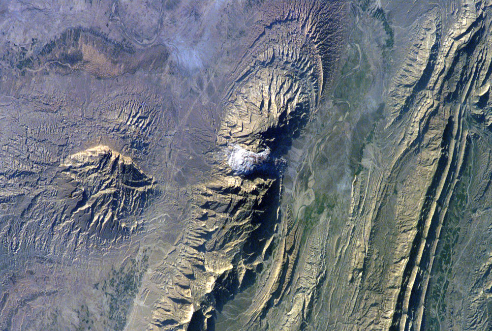
The Zagros Mountains in southwestern Iran present an impressive landscape of long linear ridges and valleys. Formed by collision of the Eurasian and Arabian tectonic plates, the ridges and valleys extend hundreds of kilometers. Stresses induced in the Earth’s crust by the collision caused extensive folding of the preexisting layered sedimentary rocks. Subsequent erosion removed softer rocks, such as mudstone (rock formed by consolidated mud) and siltstone (a slightly coarser-grained mudstone) while leaving harder rocks, such as limestone (calcium-rich rock consisting of the remains of marine organisms) and dolomite (rocks similar to limestone containing calcium and magnesium). This differential erosion formed the linear ridges of the Zagros Mountains. The depositional environment and tectonic history of the rocks were conducive to the formation and trapping of petroleum, and the Zagros region is an important part of Persian Gulf production.
This astronaut photograph of the southwestern edge of the Zagros mountain belt includes another common feature of the region—a salt dome (Kuh-e-Namak or “mountain of salt” in Farsi). Thick layers of minerals such as halite (common table salt) typically accumulate in closed basins during alternating wet and dry climatic conditions. Over geologic time, these layers of salt are buried under younger layers of rock. The pressure from overlying rock layers causes the lower-density salt to flow upwards, bending the overlying rock layers and creating a dome-like structure. Erosion has spectacularly revealed the uplifted tan and brown rock layers surrounding the white Kuh-e-Namak to the northwest and southeast (center of image). Radial drainage patterns indicate another salt dome is located to the southwest (image left center). If the rising plug of salt (called a salt diapir) breaches the surface, it can become a flowing salt glacier. Salt domes are an important target for oil exploration, as the impermeable salt frequently traps petroleum beneath other rock layers.
Astronaut photograph ISS012-E-18774 was acquired February 28, 2006, with a Kodak 760C digital camera using a 180 mm lens, and is provided by the ISS Crew Earth Observations experiment and the Image Science & Analysis Group, Johnson Space Center. The image in this article has been cropped and enhanced to improve contrast, and lens artifacts have been removed. The International Space Station Program supports the laboratory to help astronauts take pictures of Earth that will be of the greatest value to scientists and the public, and to make those images freely available on the Internet. Additional images taken by astronauts and cosmonauts can be viewed at the NASA/JSC Gateway to Astronaut Photography of Earth.
للمزيد من الصور:
https://www.facebook.com/GeologyHere.Environment/photos/a.1143642089000024/1143643312333235/?type=3&theater


